
XTEK presents XTatlas: Generate digital maps and 3D models in minutes from your Tactical Drone
by HighCom Ltd on 22/08/2018 8:04 AM
With the emergence of tactical Small Unmanned Aerial Systems (SUAS) on the battlefield, data in the tactical digital domain is being developed at unprecedented and rapidly increasing rates. For soldiers and commanders in the field, this means that the technological burden on them is greater than ever. Without a means to exploit live data from multiple sources simply and efficiently, time-sensitive data generated often goes to waste, or its importance is degraded by time.
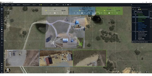
XTatlas solves the problems of handling large amounts of SUAS video or other ISR data in the field allowing accurate real-time visualisation and exploitation of data to enable rapid and informed decision making. Soldiers can visualise the data in real-time in a GIS environment in their SUAS ground station or remotely on a tactical network creating enhanced situational awareness, generating reliable and current tactical data and intelligence pictures; and perform detailed environmental analysis before committing resources to the task.
Commanders can visually plan and control their operations and communications with simple tools like the line of sight tool and the restricted operational zone (ROZ) tool as well as employ the Mil symbology feature to export real-time data over thin pipelines. Data can be generated, interrogated and exploited using simple tools to bring a new real-time tactical capability to SUAS users.
XTatlas allows users to:
- generate orthorectified georeferenced tactical maps in minutes with your own existing SUAS fleet and export to other users in real time;
- generate accurate DEM models from your SUAS reconnaissance mission for tactical planning;
- generate near real-time 3D models in minutes from live video of target buildings and vehicles at night using SUAS IR camera;
- detect and map environmental data using the SARBI sensor payload, which provides seamless CBRNE capability to existing SUAS fleet;
- enhance the intelligence picture in real time for actionable intelligence from multiple SUAS live video feeds and rapidly export into other domains; and
- use the cataloguing and search features during and post operation to select and filter the data relevant to new rapid mission and operational planning.
Data tools in XTatlas enhance the utilisation of battlefield communication systems by reducing data transmission to a manageable size to deliver the right data set to the right stakeholder for timely decision making. XTatlas works with most tactical SUAS without any modifications to existing payloads and interfaces to the ground station via a live video feed.
For more information contact XTEK today www.xtek.net/unmanned-aerial-systems/xtatlas


